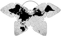
Cahill 1909
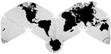
Cahill-Keyes 1975
|
Cahill 1909
|
Go back to
Gene Keyes home page
Cahill-Keyes 1975 |
Gene Keyes1973-08-10 10 Principles for a Coherent World Map System
Précis
Most world maps are notoriously distorted
and open-ended. Most other political- historical maps are a chaos of
unrelated projections and perspectives, scales and sizes, grids and
graticules, shapes and formats: orphans with no complete parent world
map nor globe. Regional sections focus on Europe or America; shrink Africa
and Asia. So-called "authoritative" political maps are seldom available,
except as secret weapons of international conflict. Thus, geopolitical
ignorance remains endemic, however well-drawn a particular map,
series, atlas, or GIS specimen.
To facilitate comprehension of the entire earth as a finite frame of natural and human events, a "Coherent World Map System" is herewith propounded. All of its sub-squares are based on the same Master World Profile (revised Cahill projection) in a specified scale progression from tiny to giant; at constant sizes, perspectives, and graticules; with geocells of 1° or at least 5°; and formatted so that hierarchical miniatures relate all main maps and globes in the system to one another: the whole earth to the street where you live. All panels belong to a millimeter matrix on a proposed 1/1,000,000 "Megamap" version 40 meters long, and its correlates: reduced, enlarged, or detached. The Coherent World Map System is engendered by the precise interlinkage of these ten requisites: 1) PROJECTION: The Master World Profile, encompassing
every map in the system, is B.J.S. Cahill's octahedronal transformation
(1909), as modified by Gene Keyes in 1975 (top of page; also, large diagram here). Despite
gradated compression averaging 14% of nominal scale, the design evinces
better felicity, symmetry, and overall fidelity to a globe than any other
single-world-map projection. It shows every continent unbroken, as well
as all 64,800 one-degree geocells in close proportion to each other.
2) SCALE: The system has 15 main scales, in a macro-micro range of 30, increasing at a 2× - 2× - 2.5× progression from a moon's-eye view of the earth (1:2,000,000,000) to a mole's-eye view (l : 0.5). (See table below.) 3) SIZE: The system has 12 set sizes (4 back-up, 4 main, 4 super), increasing at the same progression, from a one centimeter cell to the 40 meter Megamap. (See table below.) 4) SHAPE: All panels in the system are square. Besides graphic consistency, this shape enables: (a) the viewer's apparent altitude to equal the map's kilometer span;(.A rectangular exception can be made for doub1e-square world maps at super sizes where ceiling heights or floor space constraints are a factor.) 5) PERSPECTIVE: To enhance the viewer's perception of the earth's entirety as well as its finitude, the system emphasizes: (a) The delimited, self-enclosing nature of the Cahill-Keyes world profile: its octants are pre-numbered to form a "Basic Eight" for the learner's mental grasp of the planet; they can be re-arranged into other patterns and extensions. 6) GRID: The system's nexus is the 1/1,000,000 Master World Profile, the Megamap, as inscribed within the length of a 40,000 x 40,000 millimeter grid. A corresponding matrix recurs in every other panel of the system. The grid can: (a) specify the map equivalent of any square kilometer on earth with an 11-character lower-left coordinate, e.g., my old Halifax neighborhood: 12879x24899. (Three more decimal places could specify any square meter on earth); 7) GRATICULE: The system's graticular design emphasizes visibility, symmetry, regularity, and proportionality; all maps are to show a complete 1° graticule at scales of 1/20,000,000 or larger, and 5° for the 3 smaller main scales, including globes. While the Master World Profile has a conventional north-up alignment, the sub-maps' meridians are not necessarily vertical, and tend toward 60° either way, incident to the x-axis of the grid. 8) GEOCELLS: Defined hereby as one degree of latitude and longitude, geocells are central to the Cahill-Keyes map design. Its touchstone is proportionality of each adjacent geocell, one to the next. Not only does the System insist upon 1° or at least 5° resolution, but also that rows and columns of geocells not deviate perceptibly in height or width from their contiguous counterparts (while allowing for the projection's gradual shrinkage toward the center of each octant). 9) FORMAT: The system's map sets exhibit these graphic determinants: (a) Conspicuous scale distinction, re-accentuated by the grid-cell size; 10) SYNOPTIC GLOBAL FIDELITY Creating a globe/map partnership, the system calls for a) complementary octant-marked 1° or at least 5° political globes at the same scale as counterpart world maps; in particular, globes with diameters in inches of 2.5, 5, 10, 25, and 50. (See table below; inches happen to work better than centimeters as a globe diameter with metric scales, e.g., 1/50,000,000 is a 10-inch globe.) In short, the Coherent World Map System derives all of its offspring from a single Master World Profile, dovetailing them with corresponding globes and satellite imagery. It could provide a common canvas for world history and current affairs; it could help renovate geography teaching and social studies mapwork. Appendix 1:
Table of Scales and Sizes For the Coherent World Map System
Appendix 2:
These are some related papers I have presented or circulated: 1) "Six Principles for a Unified Map System" (Canadian Association of Geographers Annual Meeting, Toronto, 1974-05) 7 p. 2) "Prospectus for a Unified Map System" (International Studies Association Annual Meeting, Washington, D.C., 1975~02) 5 p. + 2 wall maps. 3) "World Maps, World Politics, and World Vision: An Appreciation of B.J.S. Cahill (1866-1944)" (Unpublished Paper, 1975-04; abstract online, updated 2009-06-01 in item #7 below) 46 p. 4) "Geopolitical Chaos: A Critical Survey of Historical Atlases and World Affairs Mapping" (Canadian Political Science Association Annual Meeting, London, Ontario, 1978-05) 36 p. 5) "'Mega-Map': Proposal for a 1/1,000,000 Outline Map of the World in a Single Frame" [including this précis] (Canadian Cartographic Association, Fourth Annual Meeting, York University, Toronto, 1979-05) 10 p. + 2 maps. 6) "Geocells and the Megamap" (Presented at Canadian Learned Societies Annual Meeting: Planetary Association for Clean Energy, 1983-06-02; updated 2007-03-31) 6 p. 7) "Notes on Scaling Cahill and Cahill-Keyes Maps" (1982-06-23; updated 2009-03-07) ca. 5 p. online, 2 illus. 7) "Evolution of the Dymaxion Map: An Illustrated Tour and Critique" (2009-06-15) 17 web-pages, profusely illustrated |
||||||||||||||||||||||||||||||||||||||||||||||||||||||||||||||||||||||||||||||||||||||||||||||||||||||||||||||||||||||||||||||||||||||||||||||||||||||||||||||||||||||||||||||||||||||||||||||||||||||||||||||||||||||||||||||||||||||||||||||||||||||||||||||||||||||||||||||||||||||||||||||||||||||||||||||||||||||||||||||||||||||||||||||||||||||||